

Appendix 1: Glossary
| Affordable Housing | Social rented, affordable rented and intermediate housing, provided to eligible households whose needs are not met by the market. Eligibility is determined with regard to local incomes and local house prices. Affordable housing should include provisions to remain at an affordable price for future eligible households or for the subsidy to be recycled for alternative affordable housing provision. Social rented housing is owned by local authorities and private registered providers (as defined in section 80 of the Housing and Regeneration Act 2008), for which guideline target rents are determined through the national rent regime. It may also be owned by other persons and provided under equivalent rental arrangements to the above, as agreed with the local authority or with the Homes and Communities Agency. Affordable rented housing is let by local authorities or private registered providers of social housing to households who are eligible for social rented housing. Affordable Rent is subject to rent controls that require a rent of no more than 80% of the local market rent (including service charges, where applicable). Intermediate housing is homes for sale and rent provided at a cost above social rent, but below market levels subject to the criteria in the Affordable Housing definition above. These can include shared equity (shared ownership and equity loans), other low cost homes for sale and intermediate rent, but not affordable rented housing. Homes that do not meet the above definition of affordable housing, such as “low cost market” housing, may not be considered as affordable housing for planning purposes. |
| Air Quality Management Areas (AQMA): | Areas designated by local authorities because they are not likely to achieve national air quality objectives by the relevant deadlines. |
| Ancient Woodland | An area that has been wooded continuously since at least 1600 AD. |
| Appropriate Assessment | Under the Habitats Directive (92/43/EEC) as transposed into UK law by the Conservation of Habitats and Species Regulations (2017) an Appropriate Assessment is required for any plan or project which either alone or in combination with other plans or projects, would be likely to have a significant effect on a European Site (see separate entry) and is not directly connected with the management of the site for nature conservation. |
| Article 4 Direction | A piece of legislation specific to an area which withdraws some of the automatic planning permissions granted by the General Permitted Development Order. |
| Authority Monitoring Report (AMR) | A document produced at least annually to report on the progress on the preparation of the Local Plan and monitor the policies. |
| Biodiversity | The whole variety of life on earth. It includes all species of plants and animals and the ecosystems and habitats they are part of. |
| Biodiversity Action Plans (BAPs) | Recognised programmes that address the protection and restoration of threatened species and habitats. These are prepared on a national and on a sub-regional basis and a BAP is in place for the Lancashire area. |
| Biological Heritage Site (BHS) | Biological Heritage Sites are considered the key wildlife sites in Lancashire other than designated sites of national or European importance. BHSs are identified using a set of published guidelines. Amendments to the list of sites are made by the Biological Heritage Sites review panel which comprises ecologists from the County Council, Wildlife Trust for Lancashire, Manchester and North Merseyside and Natural England. |
| Blue Infrastructure (BI) | The network of aquatic components that lie within and between cities, towns and villages which provide multiple social, economic and environmental benefits. The physical components of blue infrastructure include waterways such as rivers, streams, marshes and lakes. |
| Brownfield | See the definition of Previously Developed Land (PDL). |
| Climate Change | Climate change is a large-scale, long-term shift in the planet’s weather patterns or average temperatures. (MET office) |
| Climate change adaptation | Adjustments to natural or human systems in response to actual or expected climatic factors or their effects, including from changes in rainfall and rising temperatures, which moderate harm or exploit beneficial opportunities. |
| Climate change mitigation | Action to reduce the impact of human activity on the climate system, primarily through reducing greenhouse gas emissions. |
| Comparison Goods | Goods for which the consumer generally expects to invest time and effort and visit a range of shops before making a choice including: clothing materials and garments; shoes and other footwear; materials for maintenance and repair of dwellings; furniture and furnishings; carpets and other floor coverings; household textiles; major household appliances, whether electric or not; small electric household appliances; tools and miscellaneous accessories; glassware, tableware and household utensils; medical goods and other pharmaceutical products; therapeutic appliances and equipment; bicycles; recording media; games, toys and hobbies; sport and camping equipment; musical instruments; gardens, plants and flowers; pets and related products; books and stationery; audio-visual, photographic and information processing equipment; appliances for personal care; jewellery, watches and clocks; other personal effects. |
| Community Infrastructure Levy (CIL) | A levy allowing local authorities to raise funds from owners or developers of land undertaking new building projects in their area. |
| Concealed Households | Family units, including single adults living within ‘host’ households. |
| Conservation | (For heritage policy): The process of maintaining and managing change to a heritage asset in a way that sustains and, where appropriate, enhances its significance. |
| Conservation Area | These are ‘Areas of special architectural or historic interest, the character or appearance of which is desirable to preserve or enhance’ and are designated by the local planning authority. |
| Convenience Retailing | Relates to the purchase of everyday essential items, including confectionary, on goods in COICOP categories: food and non-alcoholic beverages, tobacco, alcoholic beverages (off-trade), newspapers and periodicals, non-durable household goods. |
| Cumulative effects | The state in which a series of repeated actions have effect greater than the sum of their individual effects; noted here especially in the location of wind turbines. |
| Curtilage | An area of land around a building. |
| Density (net) | Net site density includes only those areas which will be developed e.g. for housing and directly associated uses such as access roads within the site, private garden spaces, car parking areas, incidental open spaces and landscaping and children’s play areas where these are to be provided. It excludes major distributor roads; primary schools; adult/youth play spaces or other open spaces serving a wider area; and significant landscape buffer strips. |
| Designated Heritage Asset | A World Heritage Site, Scheduled Monument, Listed Building, Protected Wreck Site, Registered Park or Garden, Registered Battlefield or Conservation Area designated as such under the relevant legislation. |
| Development Management | Development management or development control is the process by which planning and similar applications are determined. |
| Development Plan | The statutorily adopted suite of development plan documents. In Burnley this will include the Local Plan and the Joint Lancashire Minerals and Waste Local Plan and any Neighbourhood Development Plans. |
| Development Plan Documents | An individual, separately adopted, part of the Local Plan. |
| Duty to Cooperate | The Localism Act 2011 introduced a Duty to Cooperate. Bodies subject to the Duty are required to engage constructively, actively and on an ongoing basis to maximise the effectiveness of Local and Marine Plan preparation in the context of strategic cross boundary matters. The duty to cooperate is not a duty to agree. |
| Ecological networks | These link sites of biodiversity importance. To date in Lancashire they have been defined for woodland and grassland species by Lancashire County Council’s Lancashire Environment Record Network (LERN). |
| Ecosystem services | The benefits people obtain from ecosystems such as food, water, flood and disease control and recreation. |
| Extra Care Housing | Housing designed with the needs of older people in mind with varying levels of care and support available on-site. People who live in extra care housing have their own self-contained homes and benefit from communal facilities being available. Properties can be rented, owned or part owned/rented. |
| European Site | These include candidate and designated and classified Special Areas of Conservation, Sites of Community Importance and Special Protection Areas, as defined in regulation 8 of the Conservation of Habitats and Species Regulations 2010. |
| Flood Risk Assessments (FRA) | Site specific assessments which identify the risks to a site or premises from flooding from all sources, and any risk which may arise elsewhere as a result of development. These assessments are required for development proposals which are in areas of known flood risk (e.g. in flood zones 2 and 3) and for all proposals over 1 hectare in size. |
| Geodiversity | The range of rocks, minerals, fossils, soils and landforms. |
| Green Belt | A designated area of land around built up areas that aims to prevent urban sprawl by keeping land permanently open. |
| Greenfield | Land which is not been previously developed (see previously-developed land). |
| Gypsies and Travellers | Persons of nomadic habit of life whatever their race or origin, including such persons who on grounds only of their own or their family’s or dependants’ educational or health needs or old age have ceased to travel temporarily, but excluding members of an organised group of travelling showpeople or circus people travelling together as such.(This is the definition set out in Appendix 1 of national planning policy document ‘Planning Policy for Traveller Sites August 2015’ |
| Green Infrastructure | A network of multi-functional green space and areas of water, urban and rural, which is capable of delivering a wide range of environmental and quality of life benefits for local communities. |
| Habitats of Principal Importance in England | Fifty-six habitats identified as requiring action under the UK Biodiversity Action Plan and which continue to be regarded as conservation priorities. These habitats are included in the UK Biodiversity List published by the Secretary of State under Section 41 of the Natural Environment and Rural Communities (NERC) Act which came into force on 1st Oct 2006. |
| Habitats Regulations Assessment (HRA) | Habitat Regulations Assessment is the process by which it is determined whether an Appropriate Assessment is necessary in relation to a proposed plan or project. (See also Appropriate Assessment above). |
| Heritage Asset | Is defined within the NPPF and refers to features within the historic environment. Heritage assets can be described as ‘designated heritage assets’ or ‘non-designated heritage assets’ (which are defined separately within this glossary). |
| Historic Environment | All aspects of the environment that result from the interaction between people and places through time, including surviving physical remains of past human activity, whether visible, buried or submerged, and landscape and planted or managed flora. |
| Infrastructure | In planning terms the physical structures and facilities that are required to support development. Infrastructure typically refers to matters such as roads, water, electricity, schools, doctors, etc. |
| Infrastructure Delivery Plan (IDP) | A schedule which identifies any required infrastructure needed to support a Local Plan and how this can be delivered. |
| Kyoto Protocol | International treaty that sets obligations to reduce greenhouse gas emissions. |
| Landscape Character Assessment | An assessment which identifies different landscape areas which have a distinct character based on recognisable pattern of elements, including combinations of geology, landform, soils, vegetation, land-use and human settlement. |
| Lead Local Flood Authority (LLFA) | Local Authority (in Lancashire the County Council) responsible for developing, maintaining and applying a strategy for local flood risk management in their areas and for maintaining a register of flood risk assets. They also have lead responsibility for managing the risk of flooding from surface water, groundwater and ordinary watercourses. |
| Listed Building | A building of ‘special architectural or historic interest’ included on a statutory list compiled the Secretary of State for Digital, Culture, Media and Sport. |
| Local Development Framework | The term previously used to describe the suite of planning policy documents. |
| Local Development Scheme | The Local Planning Authority’s project plan for the preparation of its Local Plan. |
| Local Enterprise Partnership (LEP) | A body, designated by the Secretary of State for Communities and Local Government, established for the purpose of creating or improving the conditions for economic growth in an area. |
| Local Nature Partnership | A body, designated by the Secretary of State for Environment, Food and Rural Affairs, established for the purpose of protecting and improving the natural environment in an area and the benefits derived from it. |
| Local Geodiversity Site (LGS) | A Lancashire-wide designation which identifies valuable local geological and geomorphological sites. Local Geodiversity Sites were formerly known as Regionally Important Geological Sites (RIGs). |
| Local Nature Reserve (LNR) | A statutory designation made under Section 21 of the National Parks and Access to the Countryside Act 1949 by principal local authorities. Parish and Town Councils can also declare local nature reserves but they must have the powers to do so delegated to them by a principal local authority. LNRs are for both people and wildlife. They are places with wildlife or geological features that are of special interest locally. |
| Local Transport Plan (LTP): | Prepared by the relevant highways authority for the area i.e. Lancashire County Council. The LTP sets out the objectives and plans for developing transport in an area. |
| Low Carbon Energy | Power produced from technologies which produce a low amount of carbon dioxide compared to fossil fuels. |
| Main river | Main rivers are watercourses designated as such on main river maps held by the Environment Agency and are generally the larger arterial watercourses. Any alteration or connection to a main river will require consent from the Environment Agency. |
| Major Development | For dwellings, a major development is one where the number of residential units to be constructed is 10 or more, or if the application does not state the number of units to be constructed, the site area is 0.5 hectares or more. For all other uses, a major development is one where the floor space to be built is 1,000 square metres or more, or where the site area is 1 hectare or more. |
| Market Housing | Private housing for rent or for sale, where the price and tenure is set in the open market. |
| Minerals Safeguarding Areas | Areas designated by the Minerals Planning Authority that cover known deposits of minerals, which are desired to be kept safeguarded from unnecessary sterilisation by non-mineral development. |
| Neighbourhood Development Plan | A statutory plan prepared by a Parish Council or Neighbourhood Forum for a particular neighbourhood area (made under the Planning and Compulsory Purchase Act 2004 as amended principally by the Localism Act 2011). |
| Objectively Assessed Needs (OAN) | An assessment of the demand e.g. for housing in a housing market area over a plan period – not taking account of the environmental capacity of an area to deliver it. |
| ONS | Office for National Statistics. |
| Optimum Viable Use | Optimum viable Use is the use which is viable, and where the changes are optimum in terms of entailing the least harm to the special interest of the heritage asset. The most profitable use may be less than optimum in terms of its impact on the heritage asset. |
| Ordinary Watercourse | Ordinary watercourses include drains, streams, ditches, and passages through which water flows that do not form part of main rivers. Main rivers are managed by the Environment Agency. Proposals involving alterations to a watercourse require permission from Lancashire County Council first. |
| Pitches and Plots for Gypsies, Travellers and Travelling Showpeople | A “pitch” means a pitch on a “gypsy and traveller” site and “plot” means a pitch on a “travelling showpeople” site (also sometimes called a “yard”). |
| Planning Obligation | A legally enforceable agreement between a planning authority and a developer, or an undertaking offered unilaterally by a developer, entered into under section 106 of the Town and Country Planning Act 1990 with the intention of helping to mitigate the negative impacts of a development proposal. |
| Previously developed land (also known as brownfield land) | Land which is or was occupied by a permanent structure, including the curtilage of developed land (although it should not be assumed that the whole of the curtilage should be developed) and any associated fixed surface infrastructure. This excludes: land that is or has been occupied by agricultural or forestry buildings; land that has been developed for minerals extraction or waste disposal by landfill purposes where provision for restoration has been made through development control procedures; land in built-up areas such as private residential gardens, parks, recreation grounds and allotments; and land that was previously-developed but where the remains of the permanent structure or fixed surface structure have blended into the landscape in the process of time. |
| Primary Shopping Area | Defined area where retail development is concentrated (generally comprising the primary and those secondary frontages which are adjoining and closely related to the primary shopping frontage). |
| Public Realm | The spaces between buildings and developments that are publicly accessible, including streets, squares, parks and open spaces. |
| Primary Shopping Frontage | Primary frontages are likely to include a high proportion of retail uses which may include food, drinks, clothing and household goods. |
| Priority Habitats and Species | Species and Habitats of Principle Importance included in the England Biodiversity List published by the Secretary of State under section 41 of the Natural Environment and Rural Communities Act 2006. |
| Protected Species | European Protected Species are animals and plants listed in Annex IV of the European Habitats Directive and protected in the UK under The Conservation of Habitats and Species Regulations (2017). Nationally Protected Species include all European Protected Species and also a large number of species which are specially protected under the Wildlife & Countryside Act (1981) or in other legislation such as the Protection of Badgers Act 1992. |
| Ramsar Site | Wetlands of international importance, designated under the 1971 Ramsar Convention. |
| Regional (Spatial) Strategy (RSS) | The previous regional planning framework which was revoked in 2013. |
| Regionally Important Geological Sites (RIGS): | These are sub regionally designated sites which are of importance for their geo- diversity (geology and geomorphology). |
| Registered Provider | Registered providers (often known as social landlords) are the bodies that own and manage social housing. They tend to be non-commercial organisations such as local authorities or housing associations. Housing associations are independent, not-for- profit organisations that can use any profit they make to maintain existing homes and help finance new ones. It is now possible for commercial organisations to build and manage social housing, although this is not yet common practice. |
| Renewable and Low Carbon Energy | Includes energy for heating and cooling as well as generating electricity. Renewable energy covers those energy flows that occur naturally and repeatedly in the environment – from the wind, the fall of water, the movement of the oceans, from the sun and also from biomass and deep geothermal heat. Low carbon technologies are those that can help reduce emissions (compared to conventional use of fossil fuels). |
| Scheduled Monument | Nationally important monuments, usually archaeological remains that enjoy protection against inappropriate development as a result of their scheduling under the Ancient Monuments and Archaeological Areas Act 1979. |
| Secondary Shopping Frontage | Secondary frontages provide greater opportunities for a diversity of uses such as restaurants, cinemas and businesses. |
| Setting of a Heritage Asset | The surroundings in which a heritage asset is experienced. Its extent is not fixed and may change as the asset and its surroundings evolve. Elements of a setting may make a positive or negative contribution to the significance of an asset, may affect the ability to appreciate that significance or may be neutral. |
| Sequential Approach (flood risk) | To locate development to avoid where possible flood risk to people and property and manage any residual risk, taking account of the impacts of climate change. |
| Sequential Test (flood risk) | The aim of the Sequential Test is to steer new development to areas with the lowest probability of flooding. Development should not be allocated or permitted if there are reasonably available sites appropriate for the proposed development in areas with a lower probability of flooding. The Strategic Flood Risk Assessment will provide the basis for applying this test. |
| Site of Special Scientific Interest (SSSI) | Sites designated nationally as being of special interest by reason of their flora, fauna, geological or physiological features and have statutory protection to preserve these features, designated by Natural England under the Wildlife and Countryside Act 1981. |
| Special Area of Conservation (SAC) | Areas given special protection under the European Union’s Habitats Directive, which is transposed into UK law by the Habitats and Conservation of Species Regulations 2017. |
| Special Protection Areas (SPA) | Areas which have been identified as being of international importance for the breeding, feeding, wintering or the migration of rare and vulnerable species of birds found within European Union countries. They are European designated sites, classified under the Birds Directive. |
| Species of Principal Importance in England | 943 species identified as requiring action under the UK Biodiversity Action Plan and which continue to be regarded as conservation priorities. These species are included in the UK Biodiversity List published by the Secretary of State under Section 41 of the Natural Environment and Rural Communities (NERC) Act which came into force on 1st Oct 2006. |
| Strategic Environmental Assessment (SEA) | A procedure (set out in the Environmental Assessment of Plans and Programmes Regulations 2004) which requires the formal environmental assessment of certain plans and programmes which are likely to have significant effects on the environment. |
| Strategic Flood Risk Assessment (SFRA) | A study carried out by one or more local planning authorities to assess the risk to an area from flooding from all sources, now and in the future, taking account of the impacts of climate change, and to assess the impact that land use changes and development in the area will have on flood risk. |
| Strategic Housing Land Availability Assessment (SHLAA) | A study to assess the overall potential for housing development in the area. It identifies specific sites with a development potential over the next 15 years and both informs the development of and monitors the performance of the Local Plan Can include employment land also. |
| Strategic Housing Market Assessment (SHMA) | Assesses the housing market within the housing market area, and considers the nature of future need and demand for market and affordable housing to inform the development of the Local Plan. |
| Supplementary Planning Document (SPD) | Documents which add further detail to the policies in the Local Plan. They can be used to provide further guidance for development on specific sites or on particular issues, such as design. Supplementary Planning Documents are capable of being a material consideration in planning decisions but are not part of the development plan. |
| Sustainability Appraisal (SA) | Sustainability Appraisal is a systematic appraisal process used to assess the social, environmental and economic effects of strategies and policies from the outset of the preparation process. |
| Sustainable Drainage Systems (SuDS) | SuDS are an approach to managing rainwater falling on roofs and other surfaces through a sequence of actions. The key objectives are to manage the flow rate and volume of surface runoff to reduce the risk of flooding and water pollution. SuDS also reduce pressure on the sewerage network and can improve biodiversity and local amenity. |
| Town Centre | Area defined on the local authority’s policies map, including the primary shopping area and areas predominantly occupied by main town centre uses within or adjacent to the primary shopping area. References (in the NPPF) to town centres or centres apply to city centres, town centres, district centres and local centres but exclude small parades of shops of purely neighbourhood significance. Unless they are identified as centres in Local Plans, existing out-of-centre developments, comprising or including main town centre uses, do not constitute town centres. |
| Transport Assessment | A comprehensive and systematic process that sets out transport issues relating to a proposed development. It identifies what measures will be required to improve accessibility and safety for all modes of travel, particularly for alternatives to the car such as walking, cycling and public transport and what measures will need to be taken to deal with the anticipated transport impacts of the development. |
| Transport Statement | A simplified version of a transport assessment where it is agreed the transport issues arising out of development proposals are limited and a full transport assessment is not required. |
| Travel Plan | A long-term management strategy for an organisation or site that seeks to deliver sustainable transport objectives through action and is articulated in a document that is regularly reviewed. |
| Travelling Showpeople | Member of a group organised for the purposes of holding fairs, circuses or shows (whether or not travelling together as such). This includes such persons who, on the grounds of their own family’s dependents’ more localised pattern of trading, educational or health needs or old age, have ceased to travel but excludes Gypsies and Travellers defined separately within this glossary. |
| Use Classes | The Town and Country Planning (Use Classes) Order 1987 (as amended) puts uses of land and buildings into various categories or ‘classes’ e.g. C3 dwellings. Changes of use within these classes do not normally require planning permission and changes between certain classes may not either (permission may still be required for any physical conversion works). |
| Veteran Tree | A tree which, because of its great age, size or condition, is of exceptional value for wildlife, in the landscape or culturally. |
Appendix 2: Reference List
Legislation
- Available at: http://www.legislation.gov.uk
National Planning Policy
- National Planning Policy Framework https://www.gov.uk/guidance/national-planning-policy-framework
- Written Ministerial Statements https://www.gov.uk/government/collections/planning-practice-guidance#other-planning-policies
- Planning Policy for Traveller Sites, 2015 https://www.gov.uk/government/publications/planning-policy-for- traveller-sites
National Planning Practice Guidance
Other National Guidance, Policy and Information
- Playing Fields Policy and Guidance (2018) Sport England https://www.sportengland.org/media/12940/final-playing-fields-policy-and-guidance-document.pdf
- Active Design: Planning for Health and wellbeing through sport and physical activity (2015) Sport England
https://www.sportengland.org/facilities-planning/active-design/ - Access to and Use of Buildings: Approved Document M (2016) Department for Communities and Local Government: https://www.gov.uk/government/publications/access-to-and-use-of-buildings-approved-document-m
- Contaminated Land Statutory Guidance (2012) Department for Environment, Food & Rural Affairs
https://www.gov.uk/government/publications/contaminated-land-statutory-guidance - National Character Areas List (2016) Natural England
http://publications.naturalengland.org.uk/category/587130 - National Character Area Profile 35 Lancashire Valleys (2013) Natural England
- National Character Area Profile 36 Southern Pennines (2012) Natural England
- Developers: Get Planning Advice on your Planning Proposals (2015) Natural England, Environment Agency and Department for Environment, Food & Rural Affairs www.gov.uk/guidance/developers-get-environmental-advice-on-your-planning-proposals
- The National Heritage List for England https://www.historicengland.org.uk/listing/the-list
- The National Heritage at Risk Register https://historicengland.org.uk/advice/heritage-at-risk/
- Lancashire Historic Environment Record http://www.lancashire.gov.uk/libraries-and-archives/archives-and-record-office/historic-environment-record.aspx
- The Setting of Heritage Assets Historic Environment Good Practice Advice in Planning Note 3 (Second Edition December 2017) Historic England https://content.historicengland.org.uk/images-books/publications/gpa3-setting-of-heritage-assets/heag180-gpa3-setting-heritage-assets.pdf/
- Enabling Development and the Conservation of Significant Places (2008), Historic England https://historicengland.org.uk/images-books/publications/enabling-development-and-the-conservation-of-significant-places/
- Environment Agency (2016) Flood Map for Planning (Rivers and Sea) https://data.gov.uk/dataset/bed63fc1-dd26-4685-b143-2941088923b3/flood-map-for-planning-rivers-and-sea-flood-zone-3
- Environment Agency (2016) Risk of Flooding Form Surface Water Map http://watermaps.environment-agency.gov.uk/
- Environment Agency (2016) Guidance Flood Risk Assessments: Climate Change Allowances http://environment-agency.gov.uk/
- Manual for Streets (2007) Department for Transport https://www.gov.uk/government/publications/manual-for-streets
- Non-statutory Technical Standards for Sustainable Urban Drainage (2015) Department for Environment, Food & Rural Affairs: https://www.gov.uk/government/publications/sustainable-drainage-systems-non-statutory-technical-standards
- Technical Housing Standards – Nationally Described Space Standards (2015) Department for Communities and Local Government https://www.gov.uk/government/publications/technical-housing-standards-nationally-described-space-standard
Regional and Sub-Regional Plans
- Joint Lancashire Structure Plan (2005) Joint Advisory Committee for Strategic Planning (Revoked) www.lancashire.gov.uk/media/297246/LCC15-Joint-Lancashire-Structure-Plan-2001-2016-adopted-March-2005.pdf
- The North West of England Plan Regional Spatial Strategy to 2021 (2008) Department for Communities and Local Government (Revoked) http://webarchive.nationalarchives.gov.uk/20100529165024/http://www.gos.gov.uk/gonw/Planning/RegionalPlanning/?a=42496
- Joint Lancashire Minerals and Waste Development Framework Core Strategy DPD (2009). Lancashire County Council http://www.lancashire.gov.uk/council/planning/local-planning-policy-for-minerals-and-waste.aspx
- Joint Lancashire Minerals and Waste Local Plan Site Allocation and Development Management Policies (2013): http://www.lancashire.gov.uk/council/planning/local-planning-policy-for-minerals-and-waste.aspx
Former Local Plan
- Burnley Local Plan Second Review (2006) Burnley Borough Council:
http://www.burnley.gov.uk/residents/planning/planning-policies/burnleys-adopted-local-plan-2006
Other Local Planning Documents
- Annual Monitoring Reports, Burnley Borough Council www.burnley.gov.uk/residents/planning/planning-policies/burnleys-emerging-local-plan/evidence-base/burnleys-annual-monitoring-report
- Local Development Scheme (LDS) (2018), Burnley Borough Council
https://www.burnley.gov.uk/sites/default/files/LDS%202018%20-%202021%20FINAL_0.pdf - Draft Infrastructure Delivery Plan (July 2017 Version 2), Burnley Borough Council
https://www.burnley.gov.uk/sites/default/files/IDP%20v2%20July%202017.pdf - Statement of Community Involvement (SCI) https://www.burnley.gov.uk/residents/planning/planning-policies/statement-community-involvement
- Local List of Buildings, Unscheduled Ancient Monuments and Gardens of Historic Interest http://www.burnley.gov.uk/sites/default/files/Burnley%27s%20Locally%20Listed%20Buildings%2C%20Unscheduled%20Ancient%20Monuments%20and%20Gardens%20of%20Historic%20Interest%20-%20Updated%202001.pdf
Supplementary Planning Guidance/ Documents and Local Development Orders (LDO)
- Burnley Aerospace Supplier Park (2013) LDO Burnley Borough Council https://www.burnley.gov.uk/residents/planning/planning-policies/local-development-orders/burnley-aerospace-supplier-park
- Children’s Day Nurseries SPG (1988) http://www.burnley.gov.uk/residents/planning/planning-policies/supplementary-planning-documents
- Design Guidance for Burnley Wood SPD (2006) Burnley Borough Council
http://www.burnley.gov.uk/residents/planning/planning-policies/supplementary-planning-documents - Design Guidance for Daneshouse, Stoneyholme, Duke Bar SPD (2006) Burnley Borough Council
http://www.burnley.gov.uk/residents/planning/planning-policies/supplementary-planning-documents - Design Guidance for South West Burnley SPD (2006) Burnley Borough Council
http://www.burnley.gov.uk/residents/planning/planning-policies/supplementary-planning-documents - Dormer Extensions SPG (1991) http://www.burnley.gov.uk/sites/default/files/Dormer%20Extensions.pdf
- Burnley Town Centre Public Realm Strategy (2011) Burnley Borough Council
http://www.burnley.gov.uk/residents/planning/planning-policies/supplementary-planning-documents - Weavers’ Triangle Public Realm Strategy SPD (2011) Burnley Borough Council
http://www.burnley.gov.uk/residents/planning/planning-policies/supplementary-planning-documents - Shop Front Security Shutters SPG (1998) http://www.burnley.gov.uk/residents/planning/planning-policies/supplementary-planning-documents
- South West Burnley Development Brief (2010) Burnley Borough Council:
http://www.burnley.gov.uk/residents/planning/planning-policies/supplementary-planning-documents
Evidence Base Studies
Housing
- Burnley SHMA Addendum 2014-based SNHP Update October 2017: Lichfields for Burnley Borough Council.
https://www.burnley.gov.uk/sites/default/files/EL1.006%20Burnley%20SHMA%20Addendum%20-%202014-based%20SNHP%20Update.pdf - Burnley Strategic Housing Market Assessment Update (2016), Nathaniel Lichfield & Partners for Burnley Borough Council http://www.burnley.gov.uk/sites/default/files/Burnley%20SHMA%20Update%20May%202016.PDF
- Burnley and Pendle Housing Needs Study and Strategic Housing Market Assessment (2013), Nathaniel Lichfield & Partners for Burnley Borough Council http://www.burnley.gov.uk/residents/planning/planning-policies/burnleys-emerging-local-plan/evidence-base/strategic-housing-market-assessment
- Gypsy, Traveller and Travelling Showpeople Accommodation Assessment Addendum (2016), Burnley Borough Council https://www.burnley.gov.uk/residents/planning/planning-policies/burnleys-emerging-local-plan/evidence-base/gypsy-traveller-and-travelling-show-people-accommodation-assessment-burnley-and-pendle
- Gypsy, Traveller and Travelling Showpeople Accommodation Assessment: Burnley and Pendle (2012), Salford Housing & Urban Studies Unit for Burnley Borough Council http://www.burnley.gov.uk/residents/planning/planning-policies/burnleys-emerging-local-plan/evidence-base/gypsy-traveller-and-travelling-show-people-accommodation-assessment-burnley-and-pendle
- Housing Land Availability (2009 – 2017) Burnley Borough Council http://www.burnley.gov.uk/residents/planning/planning-policies/burnleys-emerging-local-plan/evidence-base/housing-land-availability
- Strategic Housing and Employment Land Availability Assessment (SHLAA) (Update 1 March 2017) Burnley Borough Council http://www.burnley.gov.uk/residents/planning/planning-policies/burnleys-emerging-local-plan/evidence-base/strategic-housing-land-availability-assessment
Economy and Employment
- Burnley Employment Land Demand Study Update (2016), Nathaniel Lichfield and Partners for Burnley Borough Council https://www.burnley.gov.uk/residents/planning/planning-policies/burnleys-emerging-local-plan/evidence-base/employment-land-study
- Burnley Local Plan Viability Study, HDH Planning & Development for Burnley Borough Council, March 2017 https://www.burnley.gov.uk/residents/planning/planning-policy/burnleys-emerging-local-plan/evidence-base/local-plan-viability-assessment
- Burnley-Pendle Growth Corridor (Stage 1: Data Collection and Problem Identification Report) (2014) Jacobs for Lancashire County Council http://www.lancashire.gov.uk/media/497020/Burnley-Pendle-Growth-Corridor-Stage-1-Report.pdf
- Burnley-Pendle Growth Corridor Strategic Outline Business Case (2015) http://www.lancashirelep.co.uk/lep-priorities/transport-and-connectivity/burnley-pendle-growth-corridor.asp
Retail & Town Centres
- Retail, Leisure & Office Assessment (2013), Nathaniel Lichfield & Partners for Burnley Borough Council https://www.burnley.gov.uk/residents/planning/planning-policies/burnleys-emerging-local-plan/evidence-base/burnley-retail-office-and-leisure-assessment
- Burnley Town Centre Strategy (January 2016): https://www.burnley.gov.uk/sites/default/files/Burnley%20Town%20Centre%20Strategy%202015%20v4%20changes%20marked.%20cp%20140116docx%20CP.pdf
- Burnley Car Parking Strategy https://www.burnley.gov.uk/sites/default/files/car_park_strategy.pdf
Transport
- East Lancashire Highways and Transport Masterplan (2014) Lancashire County Council and Blackburn with Darwen Borough Council: http://www.lancashire.gov.uk/council/strategies-policies-plans/roads-parking-and-travel/highways-and-transport-masterplans/east-lancashire-highways-and-transport-masterplan
- Burnley Highways Impact Assessment Jacobs for Lancashire County Council and Burnley Borough Council March 2017 www.burnley.gov.uk/residents/planning/planning-policies/burnleys-emerging-local-plan/evidence-base/transport-studies
- South Pennines Route Based Strategy Evidence Report (2014): http://assets.highways.gov.uk/our-road-network/route-strategies/South%20Pennines.pdf
Open Space, Sports and GI
- Burnley Green Infrastructure Strategy (2013), TEP for Burnley Borough Council: http://www.burnley.gov.uk/sites/default/files/GI%20Strategy%20Report.pdf
- Burnley Play Strategy (2007-2011) Burnley Borough Council:
http://www.burnley.gov.uk/sites/default/files/PlayStrategyJan09.pdf - Rossendale, Pendle and Burnley Playing Pitch Assessment Report and Strategy 2016-2026 (2016), KKP for Pennine Lancashire Authorities: www.burnley.gov.uk/residents/parks-open-spaces/playing-pitch-strategy-2016-2026
- Green Spaces Strategy (2015), Burnley Borough Council: http://www.burnley.gov.uk/node/1910
- Indoor Sports Facility Review (2015) Burnley Borough Council: http://www.burnley.gov.uk/residents/planning/planning-policy/burnleys-emerging-local-plan/evidence-base/sports-studies
Flood Risk
- Burnley Strategic Flood Risk Assessment Level 1 (2017) Burnley Borough Council, incorporating Local Plan Potential Sites Assessment, summary report and mapping by JBA Consulting (2017)
- Burnley Strategic Flood Risk Assessment Level 2 (2017) Burnley Borough Council, incorporating Interim Level 2 Strategic Flood Risk Assessment by JBA Consulting (2017)
- https://www.burnley.gov.uk/residents/planning/planning-policies/burnleys-emerging-local-plan/evidence-base/strategic-flood-risk-assessment
- Lancashire and Blackpool Local Flood Risk Management Strategy (2014) Lancashire County Council and Blackpool Council: http://www.lancashire.gov.uk/council/strategies-policies-plans/environmental/lancashire-and-blackpool-flood-risk-management-strategy.aspx
Landscape and Green Belt
- Burnley Green Belt Review (2016) LUC for Burnley Borough Council:
http://www.burnley.gov.uk/sites/default/files/Burnley_Green_Belt_Review_Final%20Report.pdf - Lancashire County Council, 2000, Landscape Strategy: http://www.lancashire.gov.uk/council/strategies- policies-plans/environmental/landscape-strategy.aspx
Renewable Energy
- Landscape Capacity Study for Wind Energy Development in the South Pennines (2010) Julie Martin Associates for Rossendale, Burnley, Bury, Calderdale, Rochdale and Kirklees: http://www.burnley.gov.uk/sites/default/files/South%20Pennines%20Final%20Report%20CD%20version.pdf
- Landscape Guidance for Wind Turbines up to 60m high in the South and West Pennines (2013), Julie Martin Associates: https://www.burnley.gov.uk/sites/default/files/Smaller%20Turbines%20Guidance%20Final%20Guidance%20Jan%202013.pdf
- South Pennines Wind Energy Landscape Study (2014), Julie Martin Associates and LUC for Burnley Borough Council: http://www.burnley.gov.uk/sites/default/files/South%20Pennines%20Wind%20Energy%20Landscape%20Study%20Final.pdf
- Renewable and Low Carbon Energy Study (2010) Maslen Environmental for Burnley Borough Council: http://www.burnley.gov.uk/sites/default/files/Renewable%20%26%20Low%20Carbon%20Energy%20Study%20-%20Maslen%20Dec%202010.pdf
- Lancashire Sustainable Energy Study: A technical report for Lancashire County Council (2011) SQW Consultants/CLASP
- Taking Forward the Deployment of Renewable Energy: A Final Report to Lancashire County Council (2011), CLASP for Lancashire County Council: http://www.burnley.gov.uk/sites/default/files/2-%20LCC%20-Taking-forward-deployment-July-2011.pdf
- The Lancashire Climate Change Strategy 2009 – 2020 (2009) Lancashire Climate Change Partnership: http://www.lancashire.gov.uk/council/strategies-policies-plans/environmental/lancashire-climate-change-strategy.aspx
- Renewable Energy Target Setting & Policy Development: A Final Report to Lancashire County Council (2012) CLASP for Lancashire County Council: http://www.burnley.gov.uk/sites/default/files/3-%20LCC%20-%20Renewable%20Energy%20Targets%20-%20FINAL%20March%202012.pdf
Ecology
- Burnley Wildlife and Habitats Survey (2007) Golder Associates for Burnley Borough Council: http://www.burnley.gov.uk/sites/default/files/Burnley%20Wildlife%20and%20Habitat%20Survey%20Report.pdff
- Ecological Assessment of Local Plan (Issues and Options) Sites (2015) LERN/Lancashire County Council for or Burnley Borough Council: http://www.burnley.gov.uk/node/2578
- Burnley Protected Species Surveys (2013, 2014 and 2017), Burnley Borough Council:
http://www.burnley.gov.uk/node/2578 - Lancashire Ecological Networks Maps (Version 1a1) Grassland and Woodland (2016), LERN/Lancashire County Council http://www.burnley.gov.uk/residents/planning/planning-policy/burnleys-emerging-local-plan/evidence-base/ecological-networks
- Lancashire Ecological Network Approach and Analysis (Version 1a) (2015) LERN http://chorley.gov.uk/Documents/Planning/Planning%20Policy/Lancashire%20Ecological%20Network%20Approach%20and%20Analysis%20Document%20v1.pdf
- Ecological Appraisal: Former Heckenhurst Reservoir, Burnley (2017). The Greater Manchester Ecology Unit http://www.burnley.gov.uk/sites/default/files/Ecological%20Appraisal%20Former%20Heckenhurst%20Reservoir_0.pdf
- Ecological Appraisal: Land West of Smithyfield Avenue, Burnley (2017) The Greater Manchester Ecology Unit http://www.burnley.gov.uk/sites/default/files/Ecological%20Appraisal%20Land%20West%20of%20Smithyfield%20Avenue_0.pdf
- Ecological Assessment of Local Plan (Issues and Options) Sites (2015) LERN/Lancashire County Council for or Burnley Borough Council: http://www.burnley.gov.uk/node/2578
- Burnley Protected Species Surveys (2013, 2014 and 2017), Burnley Borough Council:
http://www.burnley.gov.uk/node/2578
Heritage
- A Local List of Lancashire’s Unregistered Historic Designed Landscapes (2013) Lancashire Gardens Trust with Lancashire County Council and Manchester Metropolitan University. http://www.burnley.gov.uk/sites/default/files/A%20Local%20List%20of%20Lancashires%20Unregsitered%20Historic%20Designed%20Landscapes%202013.pdf
Lancashire Extensive Urban Survey Historic Town Assessment Report – Burnley (2005) Lancashire County Council and Egerton Lea Consultancy http://www.burnley.gov.uk/sites/default/files/Lancashire%20Extensive%20Urban%20Survey%20Historic%20Town%20Assessment%20Report%20-%20Burnley.pdf - Lancashire Extensive Urban Survey Historic Town Assessment Report – Padiham (2005) Lancashire County Council and Egerton Lea Consultancy http://www.burnley.gov.uk/sites/default/files/Lancashire%20Extensive%20Urban%20Survey%20Historic%20Town%20Assessment%20Report%20-%20Padiham.pdf
- Burnley Housing Sites Rapid Heritage Assessment (2017) Lancashire Archaeological Advisory Service http://www.burnley.gov.uk/sites/default/files/Housing%20Sites%20Assessment.pdf
- Burnley Employment Sites Rapid Heritage Assessment (2017) Lancashire Archaeological Advisory Service http://www.burnley.gov.uk/sites/default/files/Employment%20Sites%20Assessment.pdf
- Burnley TC4 Rapid Heritage Assessment (2017) Lancashire Archaeological Advisory Service http://www.burnley.gov.uk/sites/default/files/TC4%20Assessment.pdf
- Lancashire Historic Landscape Characterisation Programme (2002) Lancashire County Council http://www.burnley.gov.uk/sites/default/files/Lancashire%20Historic%20Landscape%20Characterisation%20Programme%202002.pdf
Other
- Burnley’s Future: The Sustainable Community Strategy for Burnley 2017-2010 Burnley Borough Council / Burnley Action Partnership: http://www.burnley.gov.uk/about-council/our-strategies-and-policies
- Lancashire Strategic Economic Plan (2014), Lancashire Enterprise Partnership:
www.lepnetwork.net/modules/downloads/download.php?file_name=22 - Rural Masterplanning Study (2011) Burnley Borough Council & CABE:http://www.burnley.gov.uk/residents/planning/planning-policies/burnleys-emerging-local-plan/evidence-base/rural-masterplanning
Appendix 3: List of Superseded Policies
| Existing Policy Ref: | Policy Title (2006 Local Plan Second Review) | Superseded by, Policy Ref: | Superseded by, Policy title: |
|---|---|---|---|
| GP1 | Development Within the Urban Boundary | SP4 | Development Strategy |
| GP2 | Development in Rural Areas | SP4 | Development Strategy |
| GP3 | Design and Quality | SP5 | Development Quality and Sustainability |
| GP4 | Mixed Use Development | SP4 HS1 EMP1 TC2 TC4 | Development Strategy Housing Allocations Employment Allocations Development Within Burnley and Padiham Town Centres Development Opportunities in Burnley Town Centre |
| GP5 | Access For All | SP5 | Development Quality and Sustainability |
| GP6 | Landscaping and Incidental Open Space | SP5 SP6 | Development Quality and Sustainability Green Infrastructure |
| GP7 | New Development and the Control of Pollution | NE5 | Environmental Protection |
| GP8 | Energy Conservation and Efficiency | SP5 | Development Quality and Sustainability |
| GP9 | Security and Planning Out Crime | SP5 | Development Quality and Sustainability |
| GP10 | Developer Contributions | IC4 | Infrastructure and Planning Contributions |
| EW1 | Land for Business (B1), and Industrial (B2) and Warehousing (B8) Development | EMP1 EMP4 | Employment Allocations Office Development |
| EW2 | Major Retail Development Outside Burnley and Padiham Town Centre | TC2 | Development Within Burnley and Padiham Town Centres |
| EW3 | New Leisure, Tourist, Arts and Cultural Development Outside Town Centres | SP4 SP5 EMP5 | Development Strategy Development Quality and Sustainability Rural Business & Diversification |
| EW4 | Expansion and Improvement of Existing Businesses | EMP3 | Supporting Employment Development |
| EW5 | Development and Improvement of Major Industrial Estates | EMP2 EMP3 | Protected Employment Sites Supporting Employment Development |
| EW6 | Economic Improvement Areas | EMP3 | Supporting Employment Development |
| EW7 | Redevelopment of Existing Employment Land and Premises for Non-Employment Uses | EMP3 EMP4 | Supporting Employment Development Office Development |
| EW8 | Control of Hazardous Substances | NE5 | Environmental Protection |
| EW9 | Small Business, Working from Home and Community Enterprises in Residential Areas | EMP3 EMP5 | Supporting Employment Development Rural Business and Diversification |
| EW11 | Rural Diversification and Conversion of Rural Buildings for Employment Uses | EMP5 EMP6 | Rural Business and Diversification Conversion of Rural Buildings |
| H1 | Land for New Housing Development | HS1 | Housing Allocations |
| H2 | The Sequential Release of Further Housing Land for Development | SP4 | Development Strategy |
| H3 | Quality and Design in New Housing Development | HS4 SP5 | Housing Developments Development Quality and Sustainability |
| H4 | Providing a Choice of Housing in New Development | HS3 | Housing Density and Mix |
| H5 | Local Housing Needs | HS2 HS4 | Affordable Housing Provision Housing Developments |
| H6 | Housing Density | HS3 | Housing Density and Mix |
| H7 | Open Space in New Housing Development | HS4 IC4 | Housing Developments Infrastructure and Planning Contributions |
| H8 | Environmental Improvements in Existing Residential Areas | SP5 HS1 NE2 | Development Quality and Sustainability Housing Allocations Protected Open Space |
| H9 | Regenerating Urban Areas and Neighbourhoods | SP4 HS1 | Development Quality and Sustainability Housing Allocations |
| H10 | Housing for Large Families | HS5 | House Extensions and Alterations |
| H11 | Living Over Shops and Other Commercial Premises and Housing and Training Projects | TC2 | Development Within Burnley and Padiham Town Centres (for residential development in town centres) |
| H12 | Non-residential Uses in Residential Areas | SP4 EMP4 | Development Strategy Office Development |
| H13 | Extensions and Conversions of Existing Single Dwellings | HS5 | House Extensions and Alterations |
| H14 | Gardens and Backland Development | HS4 HS5 | Housing Developments House Extensions and Alterations |
| H15 | Conversion and Re-use for Flats and Bedsits | HS5 | House Extensions and Alterations |
| H16 | Gypsy and Traveller Sites | HS7 HS8 | Gypsy and Traveller Site Criteria Gypsy and Traveller Site Occupancy Condition |
| E1 | Nature Conservation – Internationally and Nationally Important Sites | NE1 | Biodiversity and Ecological Networks |
| E2 | Nature Conservation – County Biological and Geological Heritage Sites and Local Nature Reserves | NE1 | Biodiversity and Ecological Networks |
| E3 | Wildlife Links and Corridors | NE1 | Biodiversity and Ecological Networks |
| E4 | Protection of Features of Ecological Value | NE3 NE4 | Landscape Character Trees, Hedgerows and Woodlands |
| E5 | Species Protection | NE1 | Biodiversity and Ecological Networks |
| E6 | Trees, Hedgerows and Woodlands | NE4 | Trees, Hedgerows and Woodlands |
| E7 | Water Bodies and Watercourses | NE5 | Environmental Protection |
| E8 | Development and Flood Risk | CC4 | Development and Flood Risk |
| E9 | Groundwater Resources | NE5 | Environmental Protection |
| E10 | Alterations, Extensions, Change of Use and Development Affecting Listed Buildings | HE2 | Conservation and Enhancement of Designated Heritage Assets and Their Setting |
| E11 | Demolition of Listed Buildings | HE2 | Designated Heritage Assets |
| E12 | Development In, or Adjacent to, Conservation Areas | HE2 | Designated Heritage Assets |
| E13 | Demolition in Conservation Areas | HE2 | Designated Heritage Assets |
| E14 | The Designation and Amendment of Conservation Areas | HE1 | Identifying and Protecting Burnley’s Historic Environment |
| E15 | Locally Important Buildings, Features and Artefacts | HE1 HE3 | Identifying and Protecting Burnley’s Historic Environment The Conservation and Enhancement of Non-designated Heritage Assets |
| E16 | Areas of Traditional Construction | SP5 | Development Quality and Sustainability |
| E17 | Historic Parks and Gardens | HE1 HE2 | Identifying and Protecting Burnley’s Historic Environment Conservation and Enhancement of Designated Heritage Assets and Their Setting |
| E18 | Scheduled Ancient Monuments | HE4 | Scheduled Monuments and Archaeological Assets |
| E19 | Development and Archaeological Remains | HE4 | Scheduled Monuments and Archaeological Assets |
| E20 | Views | SP5 NE3 | Development Quality and Sustainability Landscape Character |
| E21 | Gateways and Throughroutes | SP5 | Development Quality and Sustainability |
| E22 | Public Art | IC4 | Infrastructure and Planning Contributions |
| E23 | Telecommunications | IC6 | Telecommunications |
| E24 | Advertisements | TC8 | Shopfront and Advertisement Design |
| E25 | Shop Fronts | TC8 | Shopfront and Advertisement Design |
| E26 | Development in the Green Belt | SP7 | Protecting the Green Belt |
| E27 | Landscape Character and Local Distinctiveness in Rural Areas and Green Belt | SP4 SP7 NE3 | Development Strategy Protecting the Green Belt Landscape Character |
| E28 | Protecting Agricultural Land and Business | SP4 | Development Strategy |
| E29 | New Agricultural Development | SP4 SP5 | Development Strategy Development Quality and Sustainability |
| E30 | Agricultural Workers Dwellings | HS6 | Agricultural Workers Dwellings |
| E31 | Wind Farms | CC2 CC3 | Suitable Areas for Wind Energy Development Wind Energy Development |
| E32 | Development of Other Renewable Energy Facilities in Rural Areas | CC1 | Renewable and Low Carbon Energy |
| E33 | Vacant and Untidy Land | NE3 NE5 | Landscape Character Environmental Protection |
| E34 | Derelict and Contaminated Land and Derelict Buildings | SP1 HS1 EMP1 NE5 | Achieving Sustainable Development Housing Allocations Employment Allocations Environmental Protection |
| E35 | Sites Generating Landfill Gas | NE5 | Environmental Protection |
| CF1 | Protection, Enhancement and Replacement of Playing Pitches | NE2 IC5 | Protected Open Space Protection and Provision of Social and Community Infrastructure |
| CF2 | Intensification of Use of Existing Sports and Recreation Provision | NE2 | Protected Open Space |
| CF3 | Protection of Existing Public Parks, Informal Recreation Areas, Major Open Areas, Play Areas and Other Areas of Open Space | NE2 | Protected Open Space |
| CF4 | Allotments and Community Gardens | IC5 | Protection and Provision of Social and Community Infrastructure |
| CF5 | Major Sports Facilities | SP5 | Development Quality and Sustainability |
| CF6 | Provision of Small Indoor Sports Facilities | SP5 IC5 | Development Quality and Sustainability Protection and Provision of Social and Community Infrastructure |
| CF7 | Outdoor Recreation and Rural Areas | SP5 EMP5 | Development Quality and Sustainability Rural Business & Diversification |
| CF8 | Equestrian Development | EMP7 | Equestrian Development |
| CF9 | Golf Related Development | SP5 SP7 NE2 | Development Quality and Sustainability Protecting the Green Belt Protected Open Space |
| CF10 | Specialist Pursuits and Noise Generating Sports | SP5 SP7 NE2 | Development Quality and Sustainability Protecting the Green Belt Protected Open Space |
| CF11 | District and Local Centres | TC6 | District Centres |
| CF12 | Local and Village Shops | SP4 EMP5 | Development Strategy Rural Business and Diversification |
| CF13 | Restaurants, Cafes, Public Houses and Hot Food Takeaways | TC7 | Hot Food Takeaways |
| CF14 | Provision, Retention, and Enhancement of Community Facilities | IC5 | Protection and Provision of Social and Community Infrastructure |
| CF15 | Burnley General Hospital | IC5 | Protection and Provision of Social and Community Infrastructure |
| CF16 | Loss of Community Health Facilities | IC5 | Protection and Provision of Social and Community Infrastructure |
| CF17 | Provision of Educational Facilities | IC5 | Protection and Provision of Social and Community Infrastructure |
| CF18 | Youth Shelters | IC5 | Protection and Provision of Social and Community Infrastructure |
| CF19 | Graveyards and Burial Places | IC5 | Protection and Provision of Social and Community Infrastructure |
| CF20 | Caravan and Camping Sites | SP5 | Development Quality and Sustainability |
| CF21 | Travelling Showpeople | HS8 | Gypsy and Traveller Site Criteria |
| TM1 | Location of Major Traffic Generating Uses | IC1 IC2 | Sustainable Travel Managing Transport and Travel Impacts |
| TM2 | Transport Assessments (TAs) | IC2 | Managing Transport and Travel Impacts |
| TM3 | Travel Plans (TPs) | IC2 | Managing Transport and Travel Impacts |
| TM4 | Transport Hierarchy Within Development Proposals | IC1 | Sustainable Travel |
| TM5 | Footpaths and Walking Within the Urban Boundary | IC1 | Sustainable Travel |
| TM14 | Taxis and Taxi Booking Offices | IC6 | Taxis and Taxi Booking Offices |
| TM15 | Car Parking Standards | IC3 | Car Parking Standards |
| TM16 | Management of Public and Private On- and Off-street Parking | IC3 | Car Parking Standards |
| TM17 | Management of Retail and Leisure Car Parking in Town Centres | IC3 | Car Parking Standards |
| BTC1 | Main Shopping Area of Burnley Town Centre | TC2 TC3 TC4 | Development Within Burnley and Padiham Town Centres Burnley Town Centre – Primary and Secondary Frontages Development Opportunities in Burnley Town Centre |
| BTC2 | Secondary Shopping Areas in Burnley Town Centre | TC2 TC3 TC4 | Development Within Burnley and Padiham Town Centres Burnley Town Centre – Primary and Secondary Frontages Development Opportunities in Burnley Town Centre |
| BTC3 | Retail Development Within Burnley Town Centre Inset Outside the Main and Secondary Shopping Areas | TC2 | Development Within Burnley and Padiham Town Centres |
| BTC4 | Office, Business, Civic and Cultural Quarter of Burnley Town Centre | TC2 TC4 | Development in Burnley and Padiham Town Centres Development Opportunities in Burnley Town Centre |
| BTC5 | Leisure and Tourism Development in Burnley Town Centre | TC2 | Development Within Burnley and Padiham Town Centres |
| BTC6 | The Weavers Triangle | TC5 | The Weavers Triangle |
| BTC7 | Kingsway / Bank Parade | EMP4 TC2 | Office Development Development in Burnley and Padiham Town Centres |
| BTC8 | Movement in Burnley Town Centre | IC1 | Sustainable Travel |
| BTC9 | Gateways and Throughroutes | SP5 | Development Quality and Sustainability |
| BTC10 | Upper Floors in Burnley Town Centres | TC2 | Development Within Burnley and Padiham Town Centres |
| BTC11 | Existing Industrial Uses in Burnley Town Centre | EMP3 TC2 | Supporting Employment Development Development Within Burnley and Padiham Town Centres |
| BTC12 | Canal and Riverside Development in Burnley Town Centre | HE3 NE3 | Non-designated Heritage Assets Landscape Character |
| BTC13 | Open Spaces in Burnley Town Centre | NE2 | Protected Open Space |
| BTC14 | Provision of Open Spaces in Major Development Proposals | IC4 NE3 SP5 | Infrastructure and Planning Contributions Landscape Character Development Quality and Sustainability |
| PTC1 | Central Area of Padiham Town Centre | TC2 | Development Within Burnley and Padiham Town Centres |
| PTC2 | Burnley Road Area of Padiham Town Centre | TC2 | Development Within Burnley and Padiham Town Centres |
| PTC3 | Church Street / Burnley Road | TC2 | Development Within Burnley and Padiham Town Centres |
| PTC4 | Movement To and Through Padiham Town Centre | IC1 | Sustainable Travel |
| PTC6 | Gateways and Throughroutes | SP5 | Development Quality and Sustainability |
| PTC7 | Riverside Development in Padiham Town Centre | NE3 | Landscape Character |
| PTC8 | Open Spaces in Padiham Town Centre | NE2 | Protected Open Space |
The following policies are considered too specific for, or no longer relevant to the new local plan:
| Existing Policy Ref: | Policy Title (2006 Local Plan Second Review) |
|---|---|
| EW10 | Development and Training Provision |
| TM6 | Walking and Horse Riding in the Countryside |
| TM7 | Cycling Network |
| TM8 | Quality Bus Routes |
| TM9 | Rail and Railway Stations |
| TM10 | East Lancashire Rapid Transit |
| TM11 | Traffic Management in Burnley Town Centre |
| TM12 | Movement of Freight |
| TM13 | Former Padiham Rail Line |
| PTC5 | Padiham Market |
Appendix 4: Designated Heritage Assets
Listed Buildings
- Burnley has 308 listed building entries on the National Heritage List for England, administered by Historic England on behalf of the Department for Digital, Culture, Media and Sport. It should be noted that this number does not truly represent the total number of listed buildings within the borough, since one listing may cover several individual buildings. Details of the borough’s Listed Buildings are accessible through the National Heritage List for England at https://historicengland.org.uk/listing/the-list/
- The listing includes the building identified on the list together with any ancillary building or structure within its curtilage and attached to it or any freestanding building or structure within its curtilage that pre-date 1 July 1948. Not all buildings have a curtilage. With those that do there will be cases where the extent of the curtilage will be clear (such as a garden boundary) but in others it may not. Further advice on curtilage can be found in the Historic England Advice Note, Listed Buildings and Curtilage.
- The National Heritage List includes a description of each building which may refer to some, but not all the important features of the building. Every part of a building is listed even if it is not included in the description. This includes the interior and any later alterations or additions.
Conservation Areas
- There are currently 10 designated Conservation Areas within the Borough. These are defined under Section 69 of the Planning (Listed Buildings and Conservation Areas) Act 1990, as “Areas of Special Architectural or Historic Interest the character or appearance of which it is desirable to preserve or enhance”. Conservation areas in the Borough are listed below and the detailed boundaries are shown on the Policies Map.
| Name | Area | Designated |
|---|---|---|
| Canalside | 34.2 ha | 1988 (Revisions 1990, 1993 and 1997) |
| Burnley Wood | 24.7 ha | 1985 |
| Harle Syke | 13.9 ha | 1977 (Revisions 1985) |
| Padiham | 13.8 ha | 1975 (Revisions 1981 and 1984) |
| Burnley Town Centre | 11.0 ha | 1992 |
| Top O’Th’ Town | 8.5 ha | 1992 |
| Worsthorne | 6.7 ha | 1978 |
| Jib Hill | 5.1 ha | 1971 |
| Hurstwood | 4.6 ha | 1973 |
| Palatine | 4.5 ha | 1977 |
Registered Parks and Gardens
- The Historic England ‘Register of Historic Parks and Gardens of special historic interest in England’ established in 1983, currently identifies 5 sites in the borough assessed to be of particular significance. All are registered Grade II and include:
- Towneley Park
- Queen’s Park
- Thompson Park
- Gawthorpe Hall Gardens
- Scott Park
Detailed descriptions of each entry are accessible through the National Heritage List for England at https://historicengland.org.uk/listing/the-list/
Scheduled Monuments
- There are currently 22 Scheduled Monuments within the Borough as follows:
| Parish | List Entry Number | Title |
|---|---|---|
| Briercliffe | 1005084 | Oakmount Mill engine and engine house, Wiseman Street |
| 1005089 | Ice House at Towneley Hall | |
| Ightenhill | 1005100 | Ightenhill Manor (site of) |
| Briercliffe | 1008916 | Small stone circle on Delf Hill |
| Briercliffe | 1008917 | Pike Low bowl barrow and site of beacon, Bonfire Hill |
| Worsthorne-with-Hurstwood | 1008918 | Bowl barrow on Hameldon Pasture |
| Worsthorne-with-Hurstwood | 1008919 | Round cairn on Hameldon Pasture |
| Worsthorne-with-Hurstwood | 1009112 | Ring cairn on Slipper Hill |
| Briercliffe | 1009113 | Bowl barrow 90m east of Twist Castle |
| Briercliffe | 1009114 | Bowl barrow 140m east of Beadle Hill |
| Briercliffe | 1009115 | Bowl barrow 140m east of Beadle Hill |
| Briercliffe | 1009116 | Saucer barrow 90m east of Ell Clough |
| Briercliffe | 1009117 | Ring cairn 25m east of Ell Clough |
| Briercliffe | 1009487 | Beadle Hill Romano-British farmstead |
| Worsthorne-with-Hurstwood | 1009488 | Two Romano-British farmsteads known as Ring Stones |
| Briercliffe | 1009497 | Twist Castle Romano-British farmstead |
| Briercliffe | 1013814 | Burwains Camp prehistoric defended settlement west of Broad Bank Hill |
| Hapton | 1013816 | Hapton Castle |
| Cliviger | 1018362 | Warren at Everage Clough 450m north east of New Copy Farm |
| Dunnockshaw | 1020666 | Hameldon Hill World War II bombing decoy, 390m north of Heights Farm |
| Cliviger | 1021252 | Thieveley lead mine 330m south west and 910m WSW of Buckleys |
| Hapton | 1432881 | Spigot mortar (Blacker Bombard) position |
Detailed descriptions of each entry are accessible through the National Heritage List for England at https://historicengland.org.uk/listing/the-list/
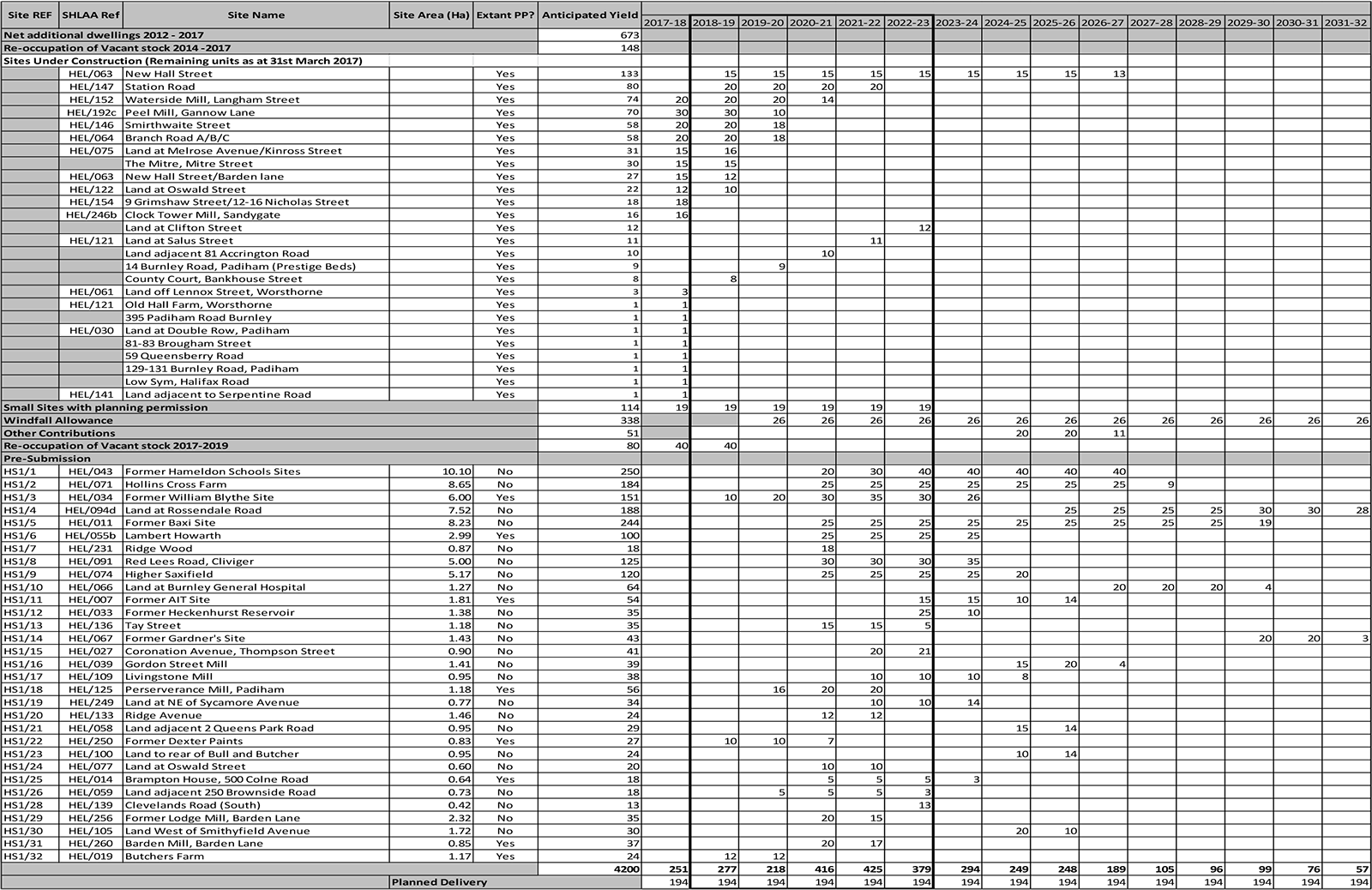
Appendix 5: Housing Trajectory
Appendix 6: Main and Small Villages (Tiers 3 and 4) – Audit of Facilities – April 2016
| Parish | Local Plan Hierarchy(Policy SP4) | Approx. No. of properties within the development boundary | Shop | School | Place of Worship | Community Building/Church Hall | Pub/Restaurant | Play Area | GP | Bus Stop | Additional Notes | 2011 Rural Masterplanning Study Conclusion |
|---|---|---|---|---|---|---|---|---|---|---|---|---|
| Main Villages (Tier 3) | ||||||||||||
| Hapton | Hapton | 784 | ✓ | ✓ | ✓ | ✓ | ✓ | ✓ | ✗ | ✓ | ||
| Worsthorne | Worsthorne | 457 | ✓ | ✓ | ✓ | ✓ | ✓ | ✓ | ✗ | ✓ | ||
| Small Villages (Tier 4) | ||||||||||||
| Dunnockshaw | Dunnockshaw | N/A | ✗ | ✗/✓ – there is a small private school | ✗ | ✗ | ✗ | ✗ | ✗ | ✓ | Employment at Oak Mill/Calder Print | Local services are scarce and there is no justification for population growth in terms of sustaining these. A large amount of development would be necessary to support new local services and, as the landscape cannot accommodate this quantum, there should be growth restraint. Small amounts of infill around existing clusters may be acceptable |
| Clow Bridge | Clow Bridge | 24 | ✗ | ✗ | ✗ | ✗ | ✓ | ✓ | ✗ | ✓ | Post box, sailing club on reservoir; employment at Balmer’s Garden Machinery | |
| Cliviger | Mereclough | 36 | ✗ | ✗ | ✗ | ✗ | ✓ | ✗ | ✗ | ✓ | Growth should be concentrated in the form of infill to Holme Chapel, including the integration of Southward Bottom. Thickening of the current ribbon of development could be beneficial and help sustain local services such as the school, parish hall, pubs. There should be no extension southwards. There should be much more restraint in the other 3 settlements | |
| Overtown | 58 | ✗ | ✗ | ✗ | ✗ | ✗ | ✓ | ✗ | ✓ | |||
| Holme Chapel | 103 | ✗ | ✓ | ✓ | ✓ | ✓ | ✗ | ✗ | ✓ | |||
| Walk Mill | 165 | ✓ | ✗ | ✗ | ✗ | ✓ | ✓ | ✗ | ✓ | Phone box; Post box; Hair Studio / Boutique; Petrol Station (where local shop is); Playground includes play park, small football pitch and basketball net; Electricity substation. | ||
| Lane Bottom | 122 | ✗ | ✗ | ✓ | ✓ | ✗ | ✓ | ✗ | ✗ | Post box; Phone box; Electricity substation | At present, there is sufficient population to sustain local services. However, there may be a case to develop the area to the south of Halifax Road to deliver a relief road for Lane Bottom | |
| Hurstwood | Hurstwood | 23 | ✗ | ✗ | ✓ | ✗ | ✗ | ✗ | ✗ | ✗ | Post box; Phone box; Church | Hurstwood is a small and distinctive settlement and can only accommodate very small and one-off developments. A small amount of infill may be accommodated on the south eastern edge of Worsthorne in order to sustain local services |
Definitions:
Local shop – Shop or facility selling basic household and grocery (convenience) goods
Play area – Equipped Play Area
Bus stop – Serviced bus stop – A bus service for this measure is one which runs at least every 30 minutes between 8am-6pm.
Appendix 7: Protected Open Spaces
| Ref: | Site Name | Ref: | Site Name |
|---|---|---|---|
| 90 | Abel Street Kickabout | 8 | Lawrence Street Allotments |
| 213 | Accrington Road (Adj 211) | 228 | Leeds & Liverpool Canal |
| 211 | Airdrie Crescent (East) | 63 | Lindsay Park Open Space |
| 215 | Albert Street Woodland | 29 | Lockyer Avenue |
| 2 | Arbories Football Ground (Club) | 127 | Lockyer Avenue Playing Fields |
| 76 | Bank Hall | 102 | Lower Manor Lane AGS |
| 43 | Barclay Hills & Griffin Clough | 32 | Lowerhouse Fold |
| 99 | Barden Gardens | 17b | Lumb Quarry Allotments |
| 100 | Barden Lane Athletics Track & Play Area | 114 | Lydgate Meadow |
| 200 | Bartle Green | 227 | Melrose Avenue AGS |
| 16 | Bedford Park (inc Dorset Ave Playground) | 217 | Millennium Gardens, Padiham |
| 207 | Brent Street Grass Area | 74 | Millennium Wood |
| 110 | Briercliffe Bowling Green & Playground | 78a | Netherwood & Rowley (BVFP) |
| 38 | Brookford Close AGS | 33 | Norfolk Avenue AGS |
| 62 | Brunshaw Avenue (Belmont Community Green) | 83 | Old Accrington Road AGS |
| 204 | Brunshaw Avenue 143-165 | 64 | Old Hall Square/Hall Street |
| 126 | Brunshaw Road/Rear Waddington Avenue | 25 | Owen Street |
| 58 | Burnley Wood Park | 115 | Padiham Greenway |
| 104 | Burns Street Playground | 5 | Padiham Memorial Park |
| 53 | Buttercross Close | 119 | Padiham Riverside Walk |
| 85 | Byerden Holme | 51 | Parklands |
| 21 | Byron Street AGS | 218 | Parliament Street |
| 86 | Calder Park | 210 | Pendle Way (Keynsham Gr/Hargrove Av) |
| 24 | Cemetery/Crematorium Woodland | 128 | Pendle Way (Longton Rd to Hutton Dr) |
| 120 | Centenary Gardens, Padiham | 89 | Piccadilly Gardens |
| 48 | Chicken Hill Wood & Allotments | 75 | Queens Park |
| 82 | Clifton Heights | 97 | Queensgate Bowling Green |
| 55 | Creswick Avenue Playground | 68 | RACA Park Cliviger |
| 94 | Cromer Grove Kickabout | 95 | Rakehead Rec |
| 108 | Deepdale Drive | 98 | Reedley Hallows Allotments |
| 125 | Devonshire Road/Elm Street | 69 | Richard Street Playground |
| 226 | Devonshire Road/Hebrew Road | 10 | River Drive AGS |
| 96 | Disraeli Street/Pratt Street | 106 | Rochester Drive AGS |
| 111 | Douglas Way AGS | 52 | Rosehill Gardens & Playground |
| 209 | Eliza Street/Higgin Street | 49 | Scott Park |
| 124 | Elm Street/Bond Street | 61 | Sheddon Grove Playground |
| 87 | Every Street AGS & Ballcourt | 116 | St Andrew’s Church Yard |
| 13 | Fennyfold Allotments | 205 | St Andrew’s Cricket Ground |
| 1 | Fiery Wood | 14 | St John’s Cemetery |
| 50 | Forfar Street | 4 | St Leonard’s Cemetery |
| 27 | Gannow Rec (Life Church) | 9 | St Leonard’s Churchyard |
| 113 | Glebe Street AGSs | 81 | St Peter’s Church Yard |
| 212 | Green Lane Gardens | 15 | Stonemoor Bottom/Shaw Brook (inc Malvern Avenue PG) |
| 23 | Greenbrook/Lowerhouse Lodges | 103 | Stoneyholme Gardens |
| 91 | Grey Street Playground | 82 | Stoneyholme Rec |
| 216 | Guy Street/Rycliffe Street | 22 | Sweet Clough (inc Sweetclough Drive open space) |
| 47 | Hapton Park (Recreation Ground) | 92 | Swinless Street Gardens |
| 203 | Harefield Rise | 30 | Sycamore Avenue Sports Facilities |
| 41 | Hargher Clough Park | 88 | Tay Street |
| 7a | Hargrove Park (Formerly known as Quarry Street) | 77 | Thompson Park |
| 7b | Hargrove Park Allotments | 93 | Thornber Gardens |
| 42 | Harold Avenue AGS & Playground | 80 | Thursby/Fisher Gardens |
| 84 | Hart Street Playground | 109 | Tiverton Drive AGS |
| 206 | Heald Road | 202 | Tiverton Drive/Delamere Road |
| 56 | Healey Wood Park | 6 | Town Hill Bank |
| 78c | Heasandford Allotments | 59 | Towneley & Fulledge |
| 54 | Helm Close | 123 | Travis Street/Chai Centre |
| 107 | Higher Saxifield | 72 | Turf Moor Estate Grass Areas |
| 101 | Highfield Avenue | 220 | Turf Moor Gardens |
| 31 | Hordley Street Playground/Lowerhouse BC | 117 | Vanguard Park |
| 57 | Hufling Lane AGS | 17a | Victoria Rd & Printers Fold Woodland |
| 37 | Ightenhill Park | 121 | Wellfield Drive |
| 67 | Inchfield Worsthorne AGS | 3 | West Street Allotments |
| 19 | Jacky Wood | 18a | Whitegate AGS & Playground |
| 40 | Jockey Street/Cog Lane | 18b | Whitegate Allotments |
| 78b | Jubilee Meadow | 39 | Whittlefield Rec |
| 105 | Kibble Bank | 208 | Wilkie Avenue |
| 28 | Kiddrow Lane/Middlesex Aven | 65 | Worsthorne Playground |
| 36 | Lakeland Way Grass Areas | 66 | Worsthorne Village Green |
| 129 | Lancaster Drive | 70 | Wycoller Avenue |
| 201 | Langfield, Worsthorne |
Appendix 8: Transport Assessments and Travel Plans
Transport Assessments/Transport Statements
- Transport Assessments are required to assess the impact of proposals on transport infrastructure, including the capacity of roads, public transport and walking and cycling infrastructure, and to detail action to manage this impact. They are required to present qualitative and quantitative information about the anticipated transport and related environmental impacts before, during and after implementation of the proposed development, including details of the accessibility of the site by all transport modes and all users, including disabled people, and the likely modal split of journeys to and from the site.
- Where a full Transport Assessment is not necessary, a less detailed assessment in the form of a Transport Statement may be required. Whatever the scale of Transport Assessment/Statement undertaken, it should be used to inform the final design of the development and if applicable, the Full Travel Plan.
- Developers are required to demonstrate that the Transport Assessment/Transport Statement has informed the design of the proposed development and the Full Travel Plan. Development proposals should meet the identified needs and address anticipated impacts of the development through the design of the scheme, effective management, including through a Travel Plan where appropriate, and through mitigating any impacts of the scheme, including through planning contributions where appropriate.
Travel Plans
- Travel Plans are the key management tool for implementing any transport solutions highlighted by the Transport Assessment/Statement, and are one of the primary tools for mitigating negative transport impacts of development proposals. Travel Plans are required to detail the developer’s response to the Transport Assessment/Statement and deliver sustainable transport objectives with a package of measures to promote sustainable transport, including measures to achieve a shift to the most sustainable forms of transport: walking and cycling.
- Although a Travel Plan will be unique to any given site, all should contain the following:
- Background – explaining the site, location, numbers of staff and visitor/residents measures already in place or confirmed/committed
- Named Travel Plan Co-ordinator
- Baseline Data – current travel patterns to and from work, business travel undertaken during the working day, travel patterns of visitors to the site or residents trips from it
- Objectives – stating in general terms what the Plan is trying to achieve
- Travel and Infrastructure Audit – description of existing travel infrastructure and facilities and the accessibility of the site
- Targets – clearly identified targets against which the effectiveness of the Plan will be measured, or targets for its delivery. Targets should be site-specific, measurable, achievable, realistic and time related (SMART)
- Actions – detailing the proposed actions and measures for achieving the stated targets, with specific dates and named responsible person
- Promotion – how the Plan itself and specific measures will be promoted
- Monitoring – setting out arrangements for the review and monitoring of the Travel Plan to determine whether the objectives are being met; a monitoring period of at least 5 years from occupation will normally be appropriate
Framework Travel Plan
- A Framework Travel Plan is usually associated with an unoccupied or undeveloped site. It sets out the intention, timeframe and steps to be taken to develop a Full Travel Plan.
Full Travel Plan
- A Full Travel Plan requires a site or location to be occupied either in full or in part. It must incorporate all the components of a Travel Plan. Where a site isn’t fully occupied there should be a commitment to review the Travel Plan as occupation increases or when the site becomes fully occupied. No detail or content should be presumed, estimated or proxy in nature. All measures and actions included in a Full Travel Plan are expected to be implementable within the timescales specified and should not be speculative or subject to further approval.
Timescales
- Where a Travel Plan is required, the documents should be submitted at the following stages in the development process:
- Submission of planning application: Framework Travel Plan
- 6 months after first occupation or other agreed milestone: Full Travel Plan
Thresholds for Transport Assessments and Travel Plans
- Developments above the following thresholds will be required to submit a Transport Assessment, Transport Statement and a Full Travel Plan.
Table 9: Thresholds for Transport Assessments, Statements and Travel Plans
| Use Class | Transport Assessment and Travel Plan Threshold (Gross floor area in m2 unless stated) |
|---|---|
| A1 Retail | >800 |
| A1 Non Food Retail | >1500 |
| A2 Financial and professional services | >2500 |
| A3 Restaurants and cafes | >2500 |
| A4 Drinking Establishments | >600 |
| A5 Hot food takeaways | >500 |
| B1 (a) Offices other than those within A2; (b) Research and Development; and (c) Light Industry | >2500 |
| B2 General Industry | >4000 |
| B8 Storage and Distribution | >5000 |
| C1 Hotels | >100 bedrooms |
| C2 Residential Institutions, Hospitals and nursing homes | >50 bedrooms |
| C2 Residential College and school | >150 students |
| C2 Residential institutions – Institutional hostels | >400 residents |
| C3 Dwelling houses | >80 units |
| D1 Non-residential institutions | >1000 |
| D2 Assembly and Leisure | >1500 |
| Other Uses | To be determined in consultation with the local highway authority |
| Transport Statement | |
| All | ‘Major’ development not above the thresholds |
- The Council may still require that a Transport Assessment and a Full Travel Plan accompany applications for new developments below these thresholds, where the Council, in consultation with the local highway authority, considers that a development is likely to have a significant negative impact on the operation of transport infrastructure; or a cumulative impact from a number of developments in the vicinity is expected.
Appendix 9: Car Parking Standards
i. The following minimum and maximum parking standards will be used as set out in Policy IC3.
| Use Class | Broad Description | Specific Land Use | Minimum Car Parking Standards (including garages) | Maximum Car Parking Standards (gross floor space where applicable) |
|---|---|---|---|---|
| A1 | Shops | Food Retail | 1 space per 14 m² | |
| Non Food Retail | 1 space per 20 m² | |||
| Retail Warehouse | 1 space per 40 m² | |||
| A2 | Financial and Professional Services | Banks / Building Societies, Estate and Employment Agencies, Professional and Financial Services | 1 space per 30 m² | |
| A3 | Restaurants and Cafes | Restaurants and Cafes | 1 space per 5 m² of public floor area | |
| A4 | Drinking Establishments | Public Houses / Wine bars / Other Drinking Establishments | 1 space per 5 m² of public floor area | |
| A5 | Hot Food Takeaways including Drive – Through’s | Use for the sale of hot food off the premises | 1 space per 12 m² unless in a town / district centre location | |
| B1 | Business | Light Industry, Business Parks, Offices, Call Centres, Research and Development | 1 space per 30 m² | |
| B2 | General Industry | General Industry | 1 space per 45 m² | |
| B8 | Storage and Distribution | Storage or Distribution Centres, Wholesale Warehouses, Repositories | 1 space per 100 m² | |
| C1 | Hotels | Hotels, Boarding Houses and Guest Houses | 1 space per bedroom inclusive of staff provision parking | |
| C2 | Residential Institutions | Residential Care Homes / Nursing Homes | 1 space per 5 beds plus 1 space per 10 beds for visitors / staff. Note: There may be a requirement for additional car parking where a proposal includes an element of low care or where there would be a number of more “mobile” residents, in which case C3 Dwelling House Standard will apply. | |
| Residential Training Centres and Halls of Residence | 1 space per bed | |||
| Hospitals | 1 space per bed | |||
| C3 | Dwellings (including HMOs) | 1 Bedroom | 1 space per dwelling | 1 space |
| 2 Bedroom | 1.5 spaces per dwelling (one allocated and one shared between 2 units for flexible use); | 2 spaces | ||
| 3 Bedrooms | 2 spaces per dwelling | 2 spaces | ||
| 4+ Bedrooms | 3 spaces per dwelling | 4 spaces | ||
| Retirement developments | Warden assisted independent living accommodation | 1 space per 3 beds plus 1 space per 10 beds for visitors / staff | 1 space per 2 beds plus 1 space per 10 beds for visitors / staff | |
| Visitor unallocated | per dwelling | 0.25 spaces per dwelling | ||
| C4 | Houses in Multiple Occupation | As per C3 Standards | As per C3 Standards | |
| D1 | Non-Residential Institution | Art Galleries, Museums, Libraries | 1 space per 20 m² | |
| Halls and Places of Worship | 1 space per 5 m² | |||
| Schools | 1 space per 2 staff plus 1 space per 10 students | |||
| Crèche / Day Nurseries | 1.5 per 2 staff plus drop off zone (in or outside of curtilage) of 1 space per 10 children | |||
| Medical Health Facilities | 4 spaces per consulting room | |||
| D2 | Assembly and Leisure | Cinemas, Bingo and Casinos, Conference Centres, Music and Concert Halls | 1 per 5 seats | |
| General Leisure: Dance Halls (But not Night Clubs), Swimming Baths, Skating Rinks and Gymnasiums | 1 space per 22 m² | |||
| Miscellaneous / Sui-Generis | Theatres | 1 space per 5 seats | ||
| Motor Car Showrooms | 1 space per 50 m² internal showroom | |||
| Petrol Filling Stations | 1 space per pump | |||
| Taxi Booking Offices | 1 space per licenced taxi operating from the business. On-site off-street and dedicated car parking to be provided, or where this cannot be achieved spaces should be located within 100 metres of the office. | |||
| Vehicle Repair and Service Stations | 1 space per 50 m² | |||
| Charging Points for ULEV’s | Non-residential developments | 20 to 50 spaces: I bay for use by electric vehicles only > 50 spaces: Min 2 bays for use by electric vehicles only | ||
| Residential Development Schemes over 10 dwellings: | I per detached dwelling | |||
Further Guidance and Application
What constitutes a car parking space?
1. A car parking space is a clearly defined and suitably surfaced space or garage.
Dimensions
2. Each space should be 2.4m in width and 5m in length.
3. Parking spaces in front of garage doors should be a minimum of 5.5m in length to enable up and over doors to open. A relaxation of this standard to 5m may be considered depending on the type of garage door to be installed.
4. Domestic garages should be a minimum size of 3m in width x 6m* in length to enable bicycles or other storage at the rear of the garage. (*unless alternative storage is provided)
Accessing Spaces
5. A minimum 6 metres clearance is required to enable cars to reverse out of a car parking space.
Mobility parking in non-residential developments
6. Mobility parking spaces (3m by 5m) shall be provided at a minimum level of 1 per 10 car parking spaces.
7. A 1.2m hatched area is required both sides of the space (only 1 space if it is at the open end of a row) and normally 1 metre hatched area behind.
Cycle parking in residential developments
8. Adequate space within should be provided for cycle parking either within the curtilage of each dwelling or within a convenient and secure communal space.
Cycle parking in non-residential developments
9. A minimum of 1 per 10 car parking spaces is required. Long stay covered areas shall be provided on all developments employing 30 or more full or part time staff.
Motorcycle parking in non-residential developments
10. A minimum of 1 per 25 car spaces. Long stay covered areas shall be provided on all developments employing 30 or more full or part time staff.
Parking in Town Centre Locations
11. In the Town Centres of Burnley and Padiham or where schemes including redevelopment to secure the future of a heritage asset, the minimum standards (other than for taxi booking offices) may not be applied in full in cases where public parking exists nearby or where on-street parking is available and the development would not cause or exacerbate congestion, highway safety issues or on-street parking problems.
Electric Car Charging Points
12. Additional provision over and above the minimum requirements set out above will be encouraged and supported in line with Policy NE5 subject to the consideration of the townscape impact in accordance with Policy SP5 and IC5. Where these affect heritage assets, care should also be taken to avoid harm and damage to historic fabric in accordance with Policies HE2 and 3.